

Somewhere talking up a storm ⛈ l 31 l TX l Meteorologist ☈ • Weather Producer @KENS5 • #UIW • @TEGNA • Questions? 📲 rshoptaugh@kens5.com
San Antonio, TX
- Tweets 15,656
- Following 1,186
- Followers 2,309
- Likes 13,530


Pinned Tweet

Life update‼️

Ryan Shoptaugh, a native of San Antonio, will appear on KENS 5’s evening weekend newscasts as well as provide weather updates on KENS 5 digital channels. kens5.com/article/entertainm…
33
20
175
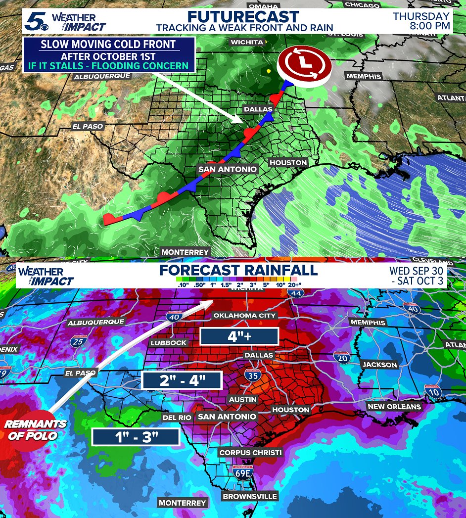
The GFS pushes the front through slightly faster by the first weekend of October while the Euro slows it down. Depending on where the cold front stalls will dictate flooding concerns. That could range anywhere from I-35 to the Hill Country, Thursday and Friday. #txwx

1
2
17
1,473
Depending on the speed of a Pacific cold front and how it clashes with tropical moisture from the leftovers of Hurricane Polo will determine more in the coming days. As of this weekend, expect increasing rain chances and cooler temperatures into October! #txwx

1
1
462
Next week's cold front will be tricky. Depending on timing, this front may stall across the region which may provoke flooding concerns into late next week. Temperature drop will be small, but rain and storms will cooll us down! Stay weather aware. #txwx
2
372
FALL COLD FRONT? 👀 While this won't be a huge push of COLD air, this will drop daytime highs into the 80s. Some guidance is even cooler by late next week! If this produces several days of clouds and rain, this will likely check out. Stay aware! Cooler weather arriving mid-week.

1
1
6
348
Astronomical Fall begins Tuesday evening (officially). Will it feel like Fall? THAT IS A NO FOR TEXAS. Daytime highs still trending 5-10 degrees above the September normal this week. #txwx

81
HOPEFULLY a weakening ridge comes to fruition this weekend taking the edge off the heat. Until then, daytime highs continue to run several degrees above the September normal! Summer continues as Fall begins this week. #txwx

1
76
LOW chances for rain continue unfortunately. If the region observes any "significant" rain, it'll be mostly east closer to Houston. Mostly scattered showers and storms. Daytime highs several degrees above normal! #txwx

2
1
301
#Norbert is currently moving west over open water, well offshore from Mexico. No immediate land impacts are expected, but Hawaii should continue to monitor the forecast as Norbert moves farther west, especially following Hurricane Lowell.

1
197
Hurricane season peak is this week! No current Atlantic development expected anytime soon. The Pacific is outscoring the Atlantic on tropical activity! #twx

1
257
Rain chances are around, BUT stay low this week. Mostly isolated daytime showers and storms in the region. High pressure strengthens into early next week. This will push daytime highs up a little into the weekend. #txwx

89
A few pop up thundershowers and storms possible this weekend. Primarily into the afternoon and evening with heating. Daytime highs a lot closer to the average for this time of year versus triple digit heat. Let's hope for some good rain! #txwx

1
1
273
These first days of September, will remain hot and humid, but less triple digit heat! Also, with a ridge farther north, this keeps the door open for disturbances to roll in from the east sparking "some" rain chances. This daily chance will go into next week. #txwx

1
306

Soaking downpours, wind damage, with some storms producing hail - it was an active overnight. Storm reports up I-35 and down I-10 with rain totals approaching 3-4" for some localized areas around San Antonio. #txwx

1
2
472
4:30 PM - Scattered showers and storms pushing south this evening! Pockets of heavy rain and lightning possible! Drive carefully! #txwx

1
2
359

RAIN THURSDAY? 🌧️The HRRR hi-res is a little more aggressive I think with this run. Regardless, daytime heat will help active scattered storms in the area tomorrow! Stay aware! #txwx

1
338
First cool-down? 👀While it won't be anytime soon, over the next few weeks, we'll be watching for any incoming fronts. It's generally late September when our first "cold" front arrives! #txwx

1
343
Although this summer has seen a good amount of rain, most of that was in June and July. No measurable rain has been picked up in San Antonio this month. Hopefully, a weak disturbance this week pops off a few showers and storms on Thursday! #txwx

1
285
The hottest weekend of the year. Let's get through it together. Go to the pool, relax indoors, go to the beach, find a way to cool off this weekend! Practice heat safety! #txwx

1
322