

🛰️🌎 Windy is an extraordinary tool for #weather #forecast visualization. It's fast, intuitive, detailed & most accurate #app trusted by #professionals
Prague
- Tweets 10,697
- Following 2,852
- Followers 74,963
- Likes 11,644




🌧️⛈️ Severe weather will affect the eastern Mediterranean and the Aegean Sea
A period of very unsettled weather is developing across parts of the eastern Mediterranean, bringing heavy rain, thunderstorms and strong winds.
The greatest risk of very heavy rainfall is currently centred on Crete, where the Hellenic National Meteorological Service (HNMS) warns of locally very heavy rain and thunderstorms, especially in northwestern Crete. These conditions may continue intermittently into the weekend.
The heavy rainfall is linked to a low-pressure system over the eastern Mediterranean, which is drawing moist air towards Crete. Combined with atmospheric instability and the island’s mountainous terrain, this can significantly enhance rainfall totals.
Very strong northeasterly winds will affect much of the Aegean Sea, locally reaching gale force and creating very rough sea conditions.
⚠️ The main hazards are intense thunderstorms, strong winds, flash flooding and dangerous conditions at sea.


6
86
9,847
🌧️⛈️ A major Mediterranean rainfall event is affecting southern France, the first of the season
Very heavy rain accompanied by thunderstorms has been affecting southern France, especially the Languedoc region, since Tuesday. Rainfall intensity may increase further today. On Thursday afternoon, the most intense storm-related rainfall is expected to gradually shift eastwards.
According to Météo-France, hourly rainfall totals in the Cévennes may reach 50–80 mm, while total rainfall over the event may reach around 200 mm, locally 250–350 mm.
⚠️ Such intense and persistent rainfall can trigger flash floods, river flooding, landslides and mudflows.
What is a Mediterranean rainfall event?
It is a period of very intense rainfall that most often affects the French Mediterranean regions in autumn. Warm, moist air from the Mediterranean Sea moves inland and, as it is forced to rise over mountainous terrain, favours the development of strong and repeated thunderstorms. Over several hours to several days, rainfall totals can therefore far exceed typical monthly amounts.
These events occur on average three to six times a year, mainly between September and December.

3
12
102
7,437
🔗Measurements from Montpellier airport
windy.com/station/ad-LFMT?43…
772
🌀 Eight tropical systems are currently active across the Atlantic and Pacific
Two tropical storms, Hanna and Fay, are active in the Atlantic. Both are weakening and are likely to dissipate over the next few days. The Atlantic hurricane season remains exceptionally inactive. No hurricane has formed so far, and the total ACE (a measure of overall tropical cyclone activity) is only around 10% of the usual value.
In the Pacific, by contrast, this season is exceptionally active, partly due to the strengthening El Niño.
Hurricane Polo, currently a Category 2 hurricane, is bringing strong winds and heavy rain to the Baja California Peninsula. Hazardous weather is shifting northeastward and will also affect northwestern mainland Mexico, where Polo is expected to weaken and dissipate. Moisture associated with its circulation may, however, reach as far as New Mexico in the United States.
Tropical Storm Rachel is strengthening over the eastern Pacific and is likely to reach hurricane intensity. Although its centre is expected to remain offshore, parts of Mexico's southwestern coast may still experience tropical-storm-force winds and locally heavy rainfall, with a risk of flooding and landslides.
Far out over the Pacific, between the Hawaiian Islands and the west coast of the Americas, tropical disturbance 91E is developing and is likely to become a tropical depression. Thunderstorm activity remains limited and disorganised for now.
Major Hurricane Nolo, currently a Category 3 hurricane, is located southwest of the Hawaiian Islands and is still generating high surf in Hawaii. It is expected to weaken as it moves north to northwest, but towards the end of this week and early next week it may still affect the Northwestern Hawaiian Islands with strong winds and high surf.
Tropical Depression 93W is developing over the western Pacific, east of the Mariana Islands. Over the coming days, it is expected to move mainly northwestward and strengthen. Early next week, it should pass near the Bonin Islands.
Tropical Storm Surigae, known in Japan as Typhoon No. 26, is moving southeast of Japan. Over the next few days, it is expected to track roughly parallel to the Japanese coast towards the northeast. During Wednesday and Thursday, it may affect the Kantō region, bringing strong wind gusts, high surf and, depending on its track, locally heavier rainfall.

2
50
255
12,131
🌀 Major Hurricane Polo reaches Category 5 again
Major Hurricane Polo has again strengthened into a Category 5 hurricane. When Polo first reached Category 5 intensity on Tuesday, 22 September, its central pressure dropped to 892 hPa, placing it among the most intense hurricanes ever recorded in the eastern Pacific.
At 7:00 AM MST (14:00 UTC) on Friday, 25 September, its centre was about 450 km (280 miles) from Manzanillo. It is moving westward, away from the Mexican coast, but the southwestern coast is still being affected by high surf and strong wind gusts.
Over the weekend, Polo is expected to turn north and then northeast. Early next week, it is forecast to strike the Baja California Peninsula. Its centre may cross the peninsula on Monday as a Category 1 or 2 hurricane.
On Tuesday, Polo will likely move over northwestern Mexico and make landfall near the Sonora-Sinaloa border.
Polo will bring strong winds, heavy rainfall and high surf, with the most significant impacts expected across the Baja California Peninsula and later in northwestern Mexico.
Moisture from Polo may also spread into the southwestern United States, contributing to heavy rainfall and a risk of flash flooding.
⚠️ Please follow the latest weather forecasts and official warnings.

1
24
151
7,190
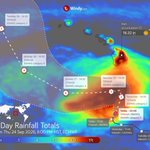
🌀 Hurricane Nolo approaches Hawaii: Catastrophic flooding threatens the Big Island
Hurricane Nolo, currently a Category 1 hurricane, is moving north-northeast towards Hawaii. At 8:00 PM on Thursday, 24 September, its centre was about 255 miles (410 km) south of South Point, Hawaii.
On Saturday, its track is expected to turn sharply westward.
Nolo is forecast to strengthen significantly and become a major hurricane over the weekend, likely reaching Category 4 intensity.
The eastern and southern parts of the Big Island are expected to see extremely heavy rainfall from Friday through Sunday. Totals of 14 to 28 inches (360 to 720 mm), locally up to 35 inches (890 mm) are forecast, bringing a risk of catastrophic and life-threatening flooding and landslides, especially in steep terrain.
On Maui, 4 to 8 inches (100 to 200 mm) are expected, locally up to 14 inches (360 mm), with life-threatening flooding and landslides possible.
Across the rest of the Hawaiian Islands, rainfall totals of up to 3 inches (75 mm) are expected, locally up to 6 inches (150 mm), with isolated flooding possible.
Other hazards on the Big Island include high surf and hurricane-force winds.
⚠️ Please follow the latest weather forecasts and official warnings.

7
27
2,985
🌀 Typhoon Dujuan approaches Japan, bringing extreme rainfall
Typhoon Dujuan, known in Japan as Typhoon No. 25, is moving parallel to the coast of Honshu, with its centre remaining roughly 100 km offshore. Sustained winds are around 121 km/h (34 m/s), with gusts reaching 150 km/h (42 m/s). The typhoon is bringing very strong winds and intense rainfall.
On Izu Oshima Island, more than 700 mm of rain fell locally within 24 hours, while hourly rainfall totals exceeded 100 mm in isolated locations. A Level 5 landslide warning was also issued for the town of Oshima in the Izu Islands.
The typhoon continues to move northeastwards and is expected to come very close to the Kanto-Koshin region overnight. Depending on its exact track, very strong winds with gusts around 90 km/h (25 m/s) are expected, with even stronger gusts over the sea. Extremely heavy rain and localised torrential downpours are also forecast, with isolated rainfall totals reaching around 200 mm. Flash flooding and landslides are possible.
On Tuesday, the typhoon is expected to move gradually farther northeastwards over the open ocean, while hazardous weather conditions across Honshu gradually ease.

3
47
191
20,028
🌀 Tropical Storm Dujuan is moving across the northwestern Pacific
After passing east of the Mariana Islands, Dujuan (known in Japan as Typhoon No. 25) is now turning northwest along the western edge of a subtropical ridge centred east of Japan.
Thursday, 17 September, 09:00 UTC:
Location: about 800 km southeast of Iwo Tō (JP)
Intensity: sustained winds 93 km/h (25 m/s), gusts 120 km/h (33 m/s)
Movement: northwest at 54 km/h (15 m/s)
Dujuan is expected to slow down while continuing northwest. During Friday and Saturday, it will pass near the Bonin Islands and may briefly strengthen into a Category 1 typhoon on the Saffir–Simpson scale, with sustained winds around 120 km/h and gusts up to 150 km/h.
It will then turn north and northeast, tracking along Japan’s eastern coast. The storm should come closest to Honshu overnight into Monday.
Main risks for eastern Honshu on Sunday and Monday:
• Gusts around 100 km/h along the Kantō coast, locally up to 120 km/h on the Izu Islands
• Rainfall of 100–200 mm, locally over 250 mm along the Pacific coast of Kantō and Tōkai and on the Izu Islands
• Waves up to 6.5 m in exposed areas
⚠️ Please follow official warnings.

5
64
4,885
💨 Windy conditions across the Mediterranean: Mistral, Tramontane and Meltemi are picking up
Local winds across the Mediterranean, including the Mistral, Tramontane and Meltemi, are strengthening.
They will continue to blow with varying intensity for several days, with gusts reaching up to 80 km/h.
They will probably ease temporarily towards the end of this week. However, they may strengthen again early next week, with the Bora potentially joining in.
🔥 Strong winds combined with dry vegetation significantly increase the risk of wildfires.
🌊 Conditions at sea will deteriorate, with waves temporarily reaching around 2 metres.
Mistral 🇫🇷
• Direction: from northerly directions
• Area: Rhône Valley and the western Mediterranean
• Typical occurrence: year-round, strongest from autumn to spring
Tramontane 🇫🇷🇪🇸
• Direction: from northerly directions
• Area: southern France, northeastern Spain, the Balearic Islands, Corsica and Sardinia
• Typical occurrence: year-round, strongest from autumn to spring
Meltemi 🇬🇷🇹🇷
• Direction: from northerly directions
• Area: mainly the Aegean Sea
• Typical occurrence: from late spring to early autumn
Bora 🇭🇷
• Direction: from the northeast
• Area: along the Adriatic coast below the Dinaric Alps
• Typical occurrence: mainly during the colder half of the year

1
2
96
7,314
🌀 A low-pressure system is deepening over the central Mediterranean, with medicane development not ruled out
A deepening low-pressure system is located over the Mediterranean Sea between Libya, Malta, southern Italy and Greece. The system is strengthening, bringing thunderstorms, strong wind gusts, intense rainfall and rough seas.
The pronounced convective system resembles a tropical depression. Whether it develops into a medicane (MEDIterranean hurriCANE) remains uncertain for now. The system would need to undergo convective restructuring and develop a distinct tropical-like character and a warm core.
The strengthening cyclone will continue moving eastwards.
On Tuesday, it may affect Greece, particularly the Peloponnese and western Crete, as well as the Ionian Islands.
On Wednesday, it may also affect eastern Crete and islands in the southern Aegean Sea.
⚠️ Please follow official warnings.

5
47
268
73,936
🌧️⛈️ Very heavy rain in western India
Severe thunderstorms are affecting India's west coast, bringing very intense rainfall and strong wind gusts.
The storms are linked to a low-pressure area over southern Rajasthan and northern Gujarat.
The most severe conditions are expected across Gujarat today (Monday) and tomorrow (Tuesday):
• Very heavy rain, locally reaching extremely heavy rainfall, with 24-hour totals exceptionally exceeding 200 mm
• Rainfall rates may exceed 15 mm per hour
• Intense rainfall may lead to flash flooding
• Thunderstorms may also produce wind gusts exceeding 60 km/h
Isolated stronger thunderstorms cannot be ruled out on Wednesday either.
⚠️ Please follow official warnings.
According to the India Meteorological Department, conditions are expected to become increasingly favourable for the southwest monsoon to withdraw from some parts of western Rajasthan later this week.

11
117
19,883
🌀 Atlantic still without a hurricane: record-late arrival of the season’s first hurricane
No hurricane has formed in the Atlantic so far this season. According to NOAA/NHC, this has never happened this late in the season since the beginning of the aircraft reconnaissance era in 1944.
Climatologically, the peak of the Atlantic hurricane season falls on 10 September. So far this season, five named storms have formed in the Atlantic. Accumulated Cyclone Energy (ACE), a metric that accounts for both tropical cyclone intensity and duration, is 93% below the 1991–2020 Atlantic average (NOAA/NHC).
Atmospheric conditions associated with El Niño are contributing to the well-below-average Atlantic activity.

3
15
102
8,890
⛈️ 🌪️ Severe thunderstorms threaten the western and central Mediterranean again
Very severe thunderstorms developed over the western Mediterranean on Wednesday (yesterday), with intense storms affecting mainly the Balearic Islands and the northern Adriatic.
On Thursday (today) and overnight into Friday, the area of possible thunderstorm development is shifting further east. Thunderstorms are expected to develop across the central Mediterranean and the northern Adriatic.
The most intense storms today are expected to affect mainly central and northern Italy, Slovenia and Croatia. An orange-level warning is also in effect in these areas.
The main threat will be heavy rainfall, as thunderstorms may repeatedly develop over the same areas. Locally, rainfall totals may exceed 150 mm, potentially causing devastating flash floods.
Thunderstorms may also produce wind gusts exceeding 100 km/h and hail larger than 4 cm. Due to the strong wind shear, organized storms including supercells may develop, and isolated tornadoes or waterspouts cannot be ruled out.
On Friday and Saturday, the area of possible thunderstorm development will shift somewhat southeastward. Storms will mainly affect southern Italy, the central and southern Adriatic Sea, and the Balkan Peninsula.
⚠️ Follow the warnings issued by local meteorological services.


1
1
19
3,323
🌕🌑 Almost a total lunar eclipse on the night of 27–28 August
At maximum, about 96% of the Moon’s disk will be inside Earth’s dark central shadow, making this a very deep partial lunar eclipse that may look almost total. Only a thin bright edge of the Moon should remain visible, while the rest may turn coppery red.
The eclipse will be visible across most of North and South America, and parts of western Europe and western Africa. In Europe and Africa, it will take place in the early morning hours, with the Moon low in the western sky.
Eclipse timeline:
• Penumbral eclipse begins: 01:23:55 UTC
• Partial eclipse begins: 02:33:48 UTC
• Maximum eclipse: 04:12:49 UTC
• Partial eclipse ends: 05:51:55 UTC
• Penumbral eclipse ends: 07:01:41 UTC
No eye protection is needed. Lunar eclipses are safe to watch with the naked eye.
☁️ Will the weather cooperate?
Check the cloud forecast for your location to see whether the sky will stay clear enough to catch the eclipse.

2
13
70
8,528
🌀 Typhoon Saudel is approaching Japan’s Okinawa and Amami islands
As the typhoon approaches, waves are increasing, especially along east-facing coasts, winds are strengthening across the islands, and heavy rain is beginning to affect the region.
The centre of the typhoon will make its closest approach to the islands around midnight tonight and is expected to pass very close to Okinoerabujima Island.
As of Tuesday, 25 August at 15:00 JST (06:00 UTC):
Location: approximately 120 km southeast of Wadomari on Okinoerabujima Island, Japan
Intensity: sustained winds of around 46 m/s (165 km/h), with gusts up to 56 m/s (200 km/h)
Movement: northwestward at approximately 6 m/s (22 km/h)
The typhoon will continue moving northwestward. On Wednesday, over the East China Sea, its track is expected to begin turning southwestward and gradually weaken. Landfall along the Chinese coast, between Ningde and Fuzhou, is expected on Friday morning. The typhoon may also affect the weather in northern Taiwan.
Threats to Okinawa and Amami:
• Rough seas and high waves: up to 11 m around the Amami Islands, 10 m around Okinawa, and 6 m near southern Kyushu
• Damaging winds: gusts may reach up to 55 m/s (200 km/h)
• Torrential rainfall: rainfall totals could exceed 250 mm locally across the Amami Islands and on Okinoerabujima, and 80 mm in parts of northern Okinawa
⚠️ Follow the latest forecasts and official warnings.

1
24
110
5,998
🌀 Pacific tropical cyclone activity is surging, while the Atlantic remains well below average
Tropical cyclone activity varies significantly across the world’s oceans. So far, activity has been highest in the northwestern Pacific, while the Atlantic remains well below average. This pattern is largely linked to the ongoing strengthening El Niño.
Northwestern Pacific: well above average
According to the Japan Meteorological Agency (JMA), 21 typhoons have formed by 24 August. The last time such a high number had been recorded by this date was in 2018. JMA currently lists 21 systems for 2026.
If the current pace continues, this season could approach the record. Since records began in 1951, the highest annual total was recorded in 1967, with 39 typhoons (JMA).
According to Colorado State University, 16 named storms have already formed in the northwestern Pacific, almost four more than usual. ACE (Accumulated Cyclone Energy), which takes into account both the intensity and duration of tropical cyclones, is currently 77% above normal.
Central Pacific: very active in recent weeks
Three named storms have already occurred in the central Pacific this year, two more than usual. ACE is well above normal, 117% higher than the long-term average (NOAA/NHC).
Eastern North Pacific: around average
So far, 9 named storms have formed in the eastern Pacific, one more than usual. Overall activity according to ACE remains close to normal, at around 9% below normal (NOAA/NHC).
Atlantic: exceptionally inactive
Only 3 named storms have been reported so far, with no hurricanes and ACE around 87% below normal (NOAA/NHC).

1
87
410
22,676
🌀 Another tropical threat approaches Hawaii
Tropical Depression Two-C is approaching the Hawaiian Islands from the southeast. It will begin affecting the Big Island as early as Saturday, followed by islands farther west. It comes roughly a week after Hurricane Lala impacted the Hawaiian Islands last weekend.
At 00:00 HST (10:00 UTC) on Friday, 21 August 2026:
Location: approximately 770 miles (1,240 km) southeast of Hilo
Intensity: maximum sustained winds around 35 mph (55 km/h), with gusts up to 50 mph (80 km/h)
Movement: west-northwest at 10 mph (17 km/h)
The tropical depression is expected to continue to strengthen and is forecast to become Tropical Storm Moke today. Over the weekend and during the first half of next week, it is forecast to move south of the Hawaiian Islands.
⚠️ Main hazards for Hawaii:
Heavy rainfall:
• Big Island: 5 to 10 in (125 to 250 mm), locally up to 15 in (375 mm)
• Maui: 1 to 2 in (25 to 50 mm), locally up to 3 in (75 mm)
• Other islands: 1 to 2 in (25 to 50 mm)
The rainfall may cause life-threatening flooding and landslides, especially in steep terrain and in areas recently affected by Lala.
Strong winds: gusts may reach around 50 mph (80 km/h) on the Big Island and Maui, with stronger gusts possible in exposed mountainous terrain.
High waves: may reach around 8 ft (2.5 m) along windward coasts and exceed 10 ft (3 m) along the southern coast of the Big Island on Sunday.
🌀 Meanwhile, Hurricane Lala, which briefly intensified to Category 2, is affecting the area around the uninhabited Laysan Island in the Northwestern Hawaiian Islands. It will move over cooler waters in the coming days and is expected to weaken significantly.

3
18
78
8,125
🌪️⛈️ Severe weather outbreak across a large part of Europe today, with the strongest storms expected in northern Italy
Ahead of a wavy cold front stretching from the Baltic region across Central Europe and the Alps towards the Iberian Peninsula, very warm and humid air is flowing into Europe from the south to the southwest.
The main conditions for strong thunderstorms are therefore in place today:
• an unstable and humid atmosphere – warm air near the surface, cooler air aloft, and plenty of moisture, especially in the lower troposphere
• a triggering mechanism provided by the wavy cold front, mountainous terrain and a jet streak in the upper troposphere
Vertical wind shear will also play an important role. Changes in wind speed and direction with height support storm organisation and increase the potential for severe weather.
Northern Italy, particularly the Po Valley, is expected to see the most favourable conditions for severe thunderstorms. The combination of strong instability (CAPE locally around 3,000 J/kg) and pronounced vertical wind shear (0–6 km bulk shear above 20 m/s) will support the development of supercell thunderstorms. They are expected to move towards Slovenia and northern Croatia along the northern Adriatic.
Damaging wind gusts, tornadoes, large to very large hail, torrential rainfall with a risk of flash flooding, and significantly worsening conditions at sea are possible.
Severe thunderstorms may also occur elsewhere in a broad belt extending from Spain across Central Europe to the Baltic region.
On Friday, the main area of thunderstorms will shift further east together with the wavy cold front. Severe to very severe thunderstorms are expected across much of Italy, Corsica, Sardinia and Sicily, as well as Tunisia, Slovenia and Croatia. Strong thunderstorms may also occur in Central Europe.
⚠️ Please follow the latest weather forecasts and official meteorological warnings.

3
7
84
7,922
🌧️ ⛈️ Heavy rainfall will affect South, Southeast and parts of East Asia in the coming days
The rainfall will be associated mainly with the southwest monsoon, several low-pressure systems, and, in part, with the tropical system Saudel, which could intensify into a typhoon. Intense downpours may cause dangerous flooding and landslides.
Significant rainfall totals may occur in the coming days, particularly in the following areas:
• India – central, northern and northeastern parts of the country and the Himalayan foothills, especially Madhya Pradesh, Uttar Pradesh, Himachal Pradesh, Bihar and Assam
• Nepal
• Bangladesh – especially the north and northeast
• Myanmar – especially the Bay of Bengal coast and mountainous areas in the north
• Thailand – especially mountainous areas in the north, west and northeast
• Cambodia – especially the Gulf of Thailand coast and the northeast
• Laos
• Vietnam – especially the north
• China – the South China Sea coast
• Taiwan
• Philippines – especially the northwest
⚠️ Please follow local weather forecasts and official warnings.

14
363
863
373,325

Hurricane Lala hits Hawaii's Big Island nitter.net/i/broadcasts/1yxBePvnL…
13
47
175
147,716