The Nor'easter continues to intensify this morning, last analyzed to 995 mb, and currently generating storm-force winds with significant wave heights to near 27 ft, or just over 8 m. Visible satellite loop along with forecast graphics and key messages included. #MarineWx
9/23 11am HST: NHC Director Dr. Michael Brennan discusses #Nolo's anticipated impacts for #Hawaii
See hurricanes.gov for the latest forecast and warning information.
11 AM HST Wed Sep 23 (Advisory 13) Key Messages for Tropical Storm #Nolo. Latest info: hurricanes.gov
ALT Key Messages:
1. Tropical Storm Nolo is expected to strengthen into a hurricane on Thursday as it moves northward, potentially making its closest approach to the Big Island of Hawaii on Saturday. A Hurricane Watch is now in effect for the Big Island, and residents there should follow advice given by local officials, including evacuating if told to do so.
2. The time to prepare for significant heavy rain and flooding impacts on the Big Island is now, as heavy rain becomes more likely by Thursday and Friday. Periods of heavy rain are likely to continue across the Big Island and Maui through the weekend. Life-threatening, catastrophic flooding and mudslides are possible, especially in areas of steep terrain across the Big Island and Maui. Across the remainder of Hawaii, lesser rainfall totals are expected, with isolated flooding possible.
3. Large and damaging waves are possible along the coast of the Big Island into the weekend.
Below is an Airmass RGB #satellite loop showing the evolution of a rapidly intensifying hurricane force low in the #Atlantic over the last 24 hours. Also attached is the latest 12z Atlantic surface analysis.
Find the latest #marine forecasts & warnings at ocean.weather.gov/
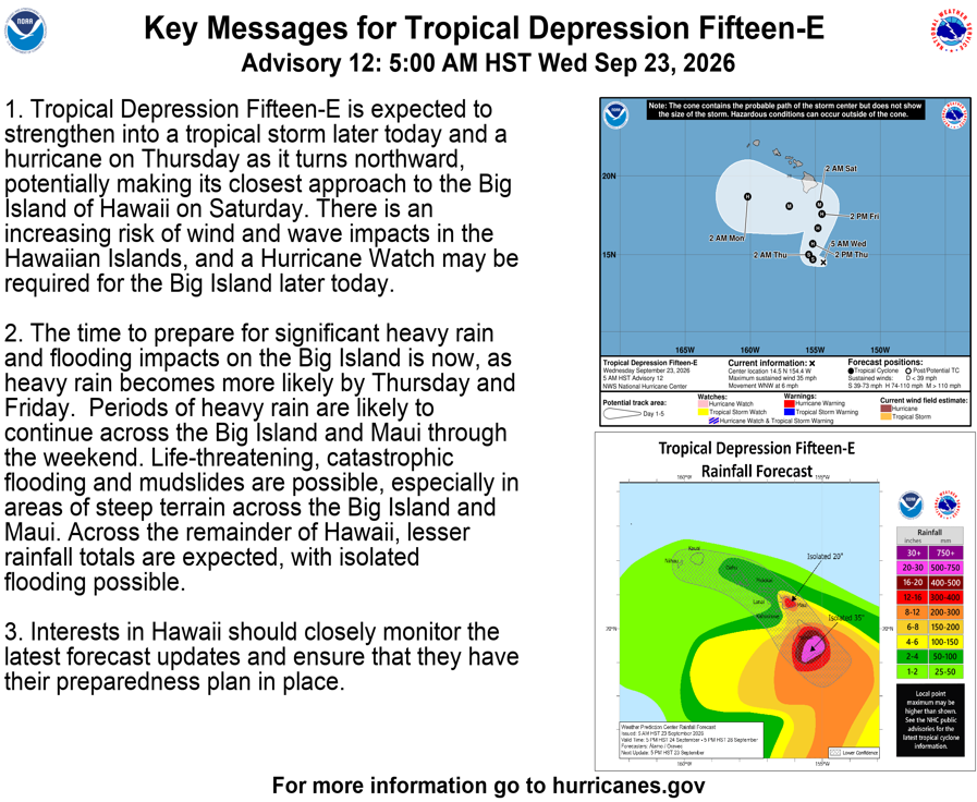
5 AM HST Wed Sep 23 (Advisory 12) Key Messages for Tropical Depression #Fifteen_E. Latest info: hurricanes.gov
ALT Key Messages:
1. Tropical Depression Fifteen-E is expected to strengthen into a tropical storm later today and a hurricane on Thursday as it turns northward, potentially making its closest approach to the Big Island of Hawaii on Saturday. There is an increasing risk of wind and wave impacts in the Hawaiian Islands, and a Hurricane Watch may be required for the Big Island later today.
2. The time to prepare for significant heavy rain and flooding impacts on the Big Island is now, as heavy rain becomes more likely by Thursday and Friday. Periods of heavy rain are likely to continue across the Big Island and Maui through the weekend. Life-threatening, catastrophic flooding and mudslides are possible, especially in areas of steep terrain across the Big Island and Maui. Across the remainder of Hawaii, lesser rainfall totals are expected, with isolated flooding possible.
Tropical Depression #Fifteen-E Advisory 12 (5 AM HST, Wed Sep 23): Interests in the Hawaiian Islands Should Closely Monitor the Progress of This System. hurricanes.gov
Hurricane-force wind warning now in effect for the deep low pressure moving off Newfoundland this morning. Primary marine hazards: Sustained winds increasing to 65 kt, along with significant wave heights building to near 30 ft. #MarineWx Latest: ocean.weather.gov/Atl_tab.ph…
Storm-force wind warning in place for deep low pressure developing east of Newfoundland. Primary marine hazards: sustained winds increasing to near 60 kt, with building seas to near 8 m (26 ft). #MarineWx
Latest Atlantic analysis and forecast info: ocean.weather.gov/Atl_tab.ph…
Check out the latest blog post' Atlantic Awakens with Extratropical Cyclone Activity', authored by Chris Smith, the CISESS GOES-R Satellite Liaison for NWS WPC/OPC! satelliteliaisonblog.wordpre… via @SatLiaisons#MarineWx
First Forecaster Friday
Meet Lauren!
She earned a BS in Atmospheric Sciences from VSU -Lyndon.
Her favorite part of being a forecaster is living out her dream. Did you know marine weather forecasting relies heavily on ship & buoy observations? Each observation is so important.
On Day of the Seafarer, we recognize the contributions of seafarers and the risks they take every day. The OPC is honored to support mariners year round in the weather challenges they face. #DayoftheSeafarer
NATIONAL MARITIME DAY: Today we celebrate the thousands of men and women throughout the world whose hard work and dedication keep the maritime industry moving forward.
From cargo and cruise operations to harbor services and marine transportation, their skill and commitment help power global commerce, support our communities and keep ports like Port Canaveral operating safely and efficiently every day. Thank you to all who serve and support the maritime industry.
#NationalMaritimeDay#WeArePortCanaveral
America needs skilled workers to build the fleet of the future. ⚓
Under @POTUS’s leadership, the Labor Department is investing millions into revitalizing our nation’s maritime workforce and shipbuilding industry.
ALT An image of a large naval ship with a visible hull number 78, in front of a seal of the United States Department of Labor. The text reads: "National Maritime Day, dol.gov"
The Port of Los Angeles is proud to celebrate National Maritime Day, recognizing the importance of the maritime sector’s essential role in supporting global trade. We acknowledge the ongoing dedication and effort across the industry that helps keep America’s No. 1 port running.
On National Maritime Day, NOAA's National Weather Service Ocean Prediction Center salutes the maritime industry and all it provides to the nation. The OPC team works hard to deliver life and property saving forecasts in support of the mariner around-the-clock every day.
Dangers remain even after the skies turn blue. This is NOT the time to put your guard down. Nearly half of hurricane fatalities occur after the storm. Here's a video detailing some dangers after the storm passes: piped.video/watch?v=XY4SfSwU…
🌀Hurricane Preparedness Week Day 5: 🌀
Be prepared for hurricane season by knowing what to do during a storm. Whether you’ve evacuated or are sheltering in place, know what to expect from the hazards you may face.
noaa.gov/stay-protected-duri…
ALT Hurricane Preparedness - Stay Protected During Storms. Stay in your safe places from water and wind. Have a way to get weather alerts and forecast updates. Keep in mind that impacts can be felt far from the coast. Listen to local officials and avoid travel unless ordered to evacuate.
Storm force wind warnings continue across the western Atlantic associated with a rapidly intensifying low pressure. Most up to date analysis/forecast info: ocean.weather.gov/Atl_tab.ph…#MarineWx